Geotagging
Our data gathering trip with the 7D tiltometer produced much smirking and several notebook pages of metadata. We went home, warmed up (eventually), and uploaded the photos to flickr (see the set here).
Next... load the data
The question of how to represent all the tilt/heading/shoesize data in triple tags/machine tags is a big one - I'll leave it to Katie to deal with that later ;)
For the time being I'll just take you through the basic geotagging process.
Step 1: Decimalise the data
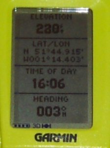
Our GPS device gave lat/long data in degrees and minutes like this:
What you are seeing there is data in degrees and minutes. I guess it made sense to somebody once, and there are probably important nautical reasons why you wouldn't want a decimal figure. Hmmm.
Either way, it's still no good for us - we need decimal values.
So, from 51°44.915 do the following:
1. Take the 44.915 (the minutes value - which is actually decimal already in our case)
2. Divide it by 60 (44.915/60 = 0.748583)
3. Add this on to the 51 (the degrees value)
4. 51 + 0.748583 = 51.748583
And that's it!
If your device gives you degrees, minutes and seconds, follow the full conversion instructions on wikipedia.
Step 2: Enter the data into flickr
The flickr map does allow you to drop photos directly onto the map but we have our own location data (that's the whole point), so...
I just went through each of the photos on flickr clicking on 'Add a tag'. For each photo I entered something like:
geotagged
geo:lon=-1.25691667
geo:long=-1.25691667
geo:lat=51.75406667
(more on lon vs long in later posts!)
Step 3: Import into the flickr map
This isn't crucial to anything we are doing at quakr, but we were eager to see where our photos would end up. To do this go here: http://flickr.com/account/geo/import.
Follow the instructions and you should get the message
"OK! Your import request has been placed in a queue. It shouldn't take too long to complete"
Step 4: Check the map!
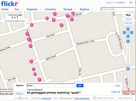
I tagged all of our photos with quakr, and doing a map search for 'quakr' brings up something very pleasing...

And that's it for the basic lat/long data. Happy geotagging!
4 comments:
Speaking about “geotagging”: do you know locr?
locr offers the ideal solution and makes geotagging exceptionally easy. locr uses GoogleMaps with detailed maps and high-resolution satellite images. To geotag your photos just enter address, let locr search, fine-tune the marker, accept position, and done! If you don’t know the exact address simply use drag&drop to set the position.
For automatic geotagging you need a datalog GPS receiver in additon to your digital camera. The GPS receiver data and the digital camera data is then automatically linked together by the locr software. All information will be written into the EXIF header.
With locr you can upload photos with GPS information in them without any further settings. In the standard view, locr shows the photo itself, plus the place it was taken. If you want to know more about the place where the photo was taken, just have at look at the Wikipedia articles which are also automatically assigned to the picture.
Have a look at www.locr.com.
Hey.
Thanks for the comment. Seems to me on investigation that your site is not offering anything more than the current flickr-yahoo map linkage, or the google earth-panoramio linkage. And unlike the flickr version (and like panoramio), you are attempting to locally host all the images uploaded. I think that might be the wrong strategy as there are soooo many people already uploading images to flickr, to ask them to upload to a second or third place with different or additional tagging seems wrong.
All the best with your development nevertheless.
Flickr import geotag tool has changed URL - correct link is http://flickr.com/account/geo/import (not http://flickr.com/account/geo/privacy/?redir=import)
Thanks for the update - I've edited the post to take that into account (!).
Post a Comment